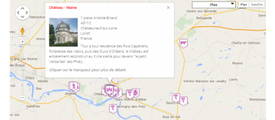
Embeds interactive maps from webris.pro: markers, GPS tracks, heatmaps, polygons, WMS layers and 29+ base maps, placed with a tag in an article or through a site module.
Webris Maps by the Webris Team shows multi-layer interactive maps on a Joomla site; the maps themselves are designed in a visual editor at webris.pro. Joomla gets no extra database tables and no admin screens: a map is attached by its ID. The extension continues the WISroGIS line, listed in JED since 2008. It suits travel, sports, local history and company websites.
Features
- A content plugin: the
{webris uuid="..." /}tag, with height, width, border and CSS classes set in the tag. - A site module for a map in a template position, each instance with its own settings.
- Layers: markers with rich popups, GPS tracks with speed and elevation profiles, polygons and lines, clusters and heatmaps, plus GeoJSON, CSV data and WMS.
- Base maps from OpenStreetMap, Carto, Esri, Google Maps, Stadia, OpenTopoMap and CyclOSM, as well as custom ArcGIS, WMTS, WMS or XYZ sources; no Google API key required.
- Categorical colouring, choropleth shading, legends, a layer switcher, measuring tools and full screen.
- A visitors layer: an anonymous city-level map of the audience with no IP addresses stored.
Compatibility
- Joomla 5 and 6.
- Current version 5.0.2, last updated in JED on 14 August 2026.
- Creating maps requires a webris.pro account (a free tier exists); maps load from the cloud as encrypted bundles.